

Maps and Formation Information for [Old] Rappahannock through Russell Counties
 [Old]
Rappahannock County was formed in 1656 from Lancaster County. It became
extinct in 1692 when it was divided in into Essex and Richmond Counties. [Back]
[Old]
Rappahannock County was formed in 1656 from Lancaster County. It became
extinct in 1692 when it was divided in into Essex and Richmond Counties. [Back]
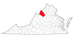
 Rappahannock
County was named for the Rappahannock River, which in turn received its
name from an Indian tribe that lived along its banks. There have
been two Virginia counties named Rappahannock. The first was created
from Lancaster in 1656 and became extinct in 1692 when it was divided into
Essex and Richmond counties. The present county was formed from
Culpeper County in 1833. Its area is 267 square miles, and the
county seat is Washington. [Back]
Rappahannock
County was named for the Rappahannock River, which in turn received its
name from an Indian tribe that lived along its banks. There have
been two Virginia counties named Rappahannock. The first was created
from Lancaster in 1656 and became extinct in 1692 when it was divided into
Essex and Richmond counties. The present county was formed from
Culpeper County in 1833. Its area is 267 square miles, and the
county seat is Washington. [Back]
 Richmond
County was named either for Richmond Borough in Surrey, England,
or for the late-seventeenth-century duke of Richmond. It
was formed from old Rappahannock County in 1692. Its area
is 203 square miles, and the county seat is Warsaw. [Back]
Richmond
County was named either for Richmond Borough in Surrey, England,
or for the late-seventeenth-century duke of Richmond. It
was formed from old Rappahannock County in 1692. Its area
is 203 square miles, and the county seat is Warsaw. [Back]
 Roanoke
County was named for the Roanoke River. The name is an
Indian word meaning shell money. The county was formed from
Botetourt County in 1838, and part of Montgomery County was added
later. Its area is 248 square miles, and the county seat is
Salem. [Back]
Roanoke
County was named for the Roanoke River. The name is an
Indian word meaning shell money. The county was formed from
Botetourt County in 1838, and part of Montgomery County was added
later. Its area is 248 square miles, and the county seat is
Salem. [Back]
 Rockbridge
County was named for Natural Bridge, an exceptional rock
formation located in the county. The county was formed from
Augusta and Botetourt counties in 1778, and another part of
Botetourt was added later. The area is 604 square miles,
and the county seat is Lexington. [Back]
Rockbridge
County was named for Natural Bridge, an exceptional rock
formation located in the county. The county was formed from
Augusta and Botetourt counties in 1778, and another part of
Botetourt was added later. The area is 604 square miles,
and the county seat is Lexington. [Back]
 Rockingham
County was named for Charles Watson-Wentworth, a second marquis
of Rockingham, who supported the colonists in their disputes with
Great Britain. It was formed from Augusta County in 1778.
Its area is 871 square miles, and the county seat is
Harrisonburg. [Back]
Rockingham
County was named for Charles Watson-Wentworth, a second marquis
of Rockingham, who supported the colonists in their disputes with
Great Britain. It was formed from Augusta County in 1778.
Its area is 871 square miles, and the county seat is
Harrisonburg. [Back]
 Russell
County was named for William Russell, a Clinch Valley pioneer and
the member of the House of Delegates who introduced the
legislation forming the county from Washington County in 1786.
Its area is 483 square miles, and the county seat is Lebanon.
[Back]
Russell
County was named for William Russell, a Clinch Valley pioneer and
the member of the House of Delegates who introduced the
legislation forming the county from Washington County in 1786.
Its area is 483 square miles, and the county seat is Lebanon.
[Back]
