|
 Virginians
in the new nation turned their energies to creating a commercial
empire that would extend Virginia's influence to the Ohio River
and beyond. Virginia and other states scrambled to create canals
and establish road systems in a race to control the potential
wealth of the trans-Appalachian interior. Throughout the 19th
century, Virginia focused on developing internal transportation
systems to funnel goods from the West to its eastern ports. Virginians
in the new nation turned their energies to creating a commercial
empire that would extend Virginia's influence to the Ohio River
and beyond. Virginia and other states scrambled to create canals
and establish road systems in a race to control the potential
wealth of the trans-Appalachian interior. Throughout the 19th
century, Virginia focused on developing internal transportation
systems to funnel goods from the West to its eastern ports.
Numerous companies attempted to raise funds for canal
construction. The James River and Kanawha
 Company was founded in 1785 at the insistence of George
Washington. After Andrew Alexander's 1814 survey of the
headwaters of the James to determine the extent to which the
James was navigable revealed the potential for development, the
commonwealth of Virginia began to oversee the internal
improvement projects. On 5 February 1816 the General Assembly
 established the Board
of Public Works and created a fund for "the purpose of
rendering navigable, and uniting by canals, the principal
rivers, and of more intimately connecting, by public highways,
the different parts of this Commonwealth." The Board of
Public Works
 invested public money in the development of the state's
infrastructure after private funds had been subscribed. With
oversight by its principal engineer, the Board developed maps as
planning documents that individuals and companies used to
develop natural resources, understand demographics, and to plan
turnpikes and railroads.
 The
commonwealth also commissioned a map of the state based on
extensive county surveys, which John Wood executed and Herman
Boye then completed and compiled. Published in 1827, their
creation served as the basic map of the state until its revision
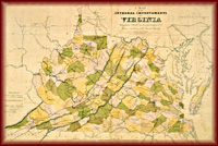
in 1859. Specialized maps, such as Claudius Crozet's internal
improvement map of 1848, detailed the routes of canals and
railroads, as well as locations of Virginia's rich coalfields,
and were distributed not only to document the internal
improvements of the state, but also to advertise the economic
potential of the commonwealth. William Barton Rogers led a
geological survey of the state from 1835 to 1841, Rogers's map
of Virginia's geological divisions remained unpublished until
1876 when Jedidiah The
commonwealth also commissioned a map of the state based on
extensive county surveys, which John Wood executed and Herman
Boye then completed and compiled. Published in 1827, their
creation served as the basic map of the state until its revision
in 1859. Specialized maps, such as Claudius Crozet's internal
improvement map of 1848, detailed the routes of canals and
railroads, as well as locations of Virginia's rich coalfields,
and were distributed not only to document the internal
improvements of the state, but also to advertise the economic
potential of the commonwealth. William Barton Rogers led a
geological survey of the state from 1835 to 1841, Rogers's map
of Virginia's geological divisions remained unpublished until
1876 when Jedidiah
 Hotchkiss
included a map based on Rogers's data in a volume on the state's
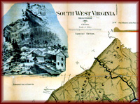
natural resources. Maps of Virginia's coalfields and iron ore
deposits, such as Charles R. Boyd's 1881 map of southwestern
Virginia, served as documents of Virginia's mineral resources
and also as enticements to development in the state's western
counties. Hotchkiss
included a map based on Rogers's data in a volume on the state's
natural resources. Maps of Virginia's coalfields and iron ore
deposits, such as Charles R. Boyd's 1881 map of southwestern
Virginia, served as documents of Virginia's mineral resources
and also as enticements to development in the state's western
counties.
|
|
Mapping Virginia

Surveyors and Mapmakers
Mapping Technology
Vision of Empire
Building the
Commonwealth
The Geography of
Culture
Educators' Lesson Plans
 |